What's the deal with the
Benguela Upwelling System?
CS 6730 Project by Daniel Muratore & Nate Knauf
Almost two-thirds of the Earth's surface is covered by the ocean. The ocean drives the Earth's climate, provides a habitat to countless animals and plants, food to millions of people around the globe, and is even the primary actor in absorbing anthropogenic CO2 emissions. Here, we're going to describe a critically important yet not-so-well-known region of the ocean, it's economic impacts, and the current state of affairs on researching its properties.
To collect large amounts of monitoring data on the ocean, we have heavily relied on satellite observations since the 1980s. Here we will be showing ocean maps of data that have all been captured by satellite measurements made publicly available via the NASA EarthData satellite portal and the EU's Copernicus Earth observations program. Through these programs we have been able to transform our capacity to take photographs like these into data.
Image courtesy of NASA
Scroll down!
What is an Eastern Boundary Upwelling System?
Welcome to the southeast Atlantic ocean. At a first glance, one may think the ocean is a plain vast blue expanse everywhere. However, this could not be further from the case. Just as the land has diverse features, climates, features, and biodiversity, so does the ocean.
Here, off of the western coast of South Africa, Namibia, and Angola, is a very special place in particular. The contrast between the temperature and air pressure on the land and over the water causes strong northwestern winds to blow offshore. These winds blow the water on the surface of the ocean further out to sea. To take the place of the empty space where that water at the surface used to be, new water from deeper in the ocean rises up to the surface. This mechanism is called Ekman pumping.
One way to see the deep water rising to the surface along the coast is by mapping the water temperature. Water from deeper in the ocean has had less time to be warmed by the sun, so in general it is colder. Here on the map you can see the cold spot right next to the coast, which is direct evidence of upwelled water.
Why does coastal upwelling matter?
The water that comes to the surface isn't quite the same as the water that had already been sitting there. The longer water stays on the ocean surface, the more of the nutrients it contains are consumed by microscopic plant-like organisms called phytoplankton. Therefore, deeper water tends to have more nutrients. An upwelling site such as the Benguela Upwelling System becomes a place where fresh nutrients are constantly being added back to the surface, like fertilizer.
Constant nutrient supply facilitates the growth of millions and millions of phytoplankton, which we can actually see from space by looking for chlorophyll, the pigment that allows them (and land plants!) to photosynthesize. We know chlorophyll absorbs a certain light wavelength and emits another (why leaves appear green), so from the satellite we can detect those wavelengths to back calculate how much chlorophyll there must be on Earth's surface.
Diatoms Thalassiosira rotula
From field observations on the ground (or at sea, as it were), we know the phytoplankton that are some of the usual suspects.
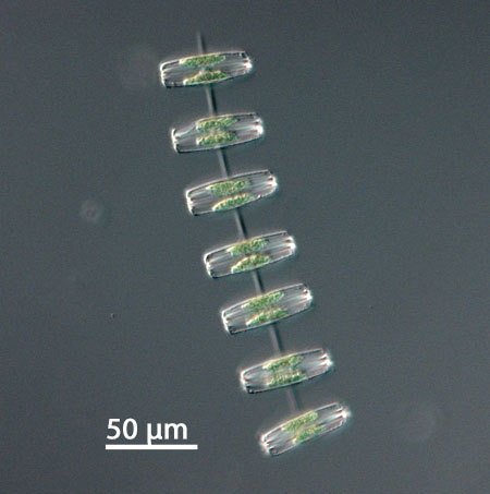
Image courtesy of marinespecies.org
Thalassiosira is a globally ubiquitous species of diatom, phytoplankton that build external shells made out of silicon. Because the external shell makes their cells relatively heavy, diatoms are an important avenue by which carbon produced by photosynthesis in the ocean surface sinks to the deep ocean.
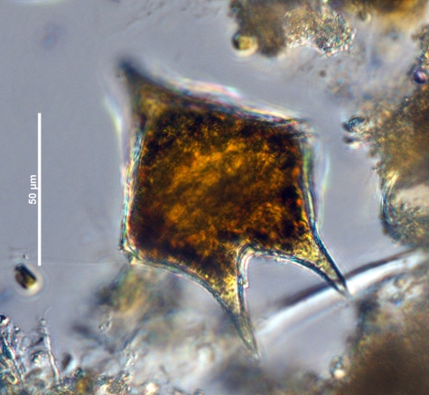
Dinoflagellates Protoperidinium
Dinoflagellates are another major component of the BUS plankton community. While less famous than their cousin, the dinoflagellate that causes red tide, Protoperidinium dinoflagellates interestingly do not only rely on photosynthesis for their energy - they are hunters as well! Dinoflagellates are well-known for a strategy called mixotrophy, which mixes photosynthesis with preying on bacteria to increase adaptability to a wide variety of environments.
(Phytoplankton community composition data collected from Hansen and Wasmund, Journal of Marine Systems 2014, Probyn Marine Ecology Progress Series 1985, Ekau et al Journal of Marine Systems 2018, Barlow et al African Journal of Marine Science 2018, Norris Transactions in the Royal Society of South Africa 1984)
Who cares about phytoplankton?
The phytoplankton that proliferate due to upwelling-induced fertilization are the favorite food of small fish, forming the base of a large marine ecosystem. In fact, the four EBUS that exist around the world (here at the Benguela, off of the coast of California, off of the coast of Peru/Chile, and around the Canary Islands between northern Africa and the Iberian peninsula) only comprise about 1% of the world's ocean surface area, but contribute around 20% of the world's fisheries.
Fish Exports (tons) over Time (year)
Map Legend, Fish Exports (tons)
Number of Fishers over Time (year)
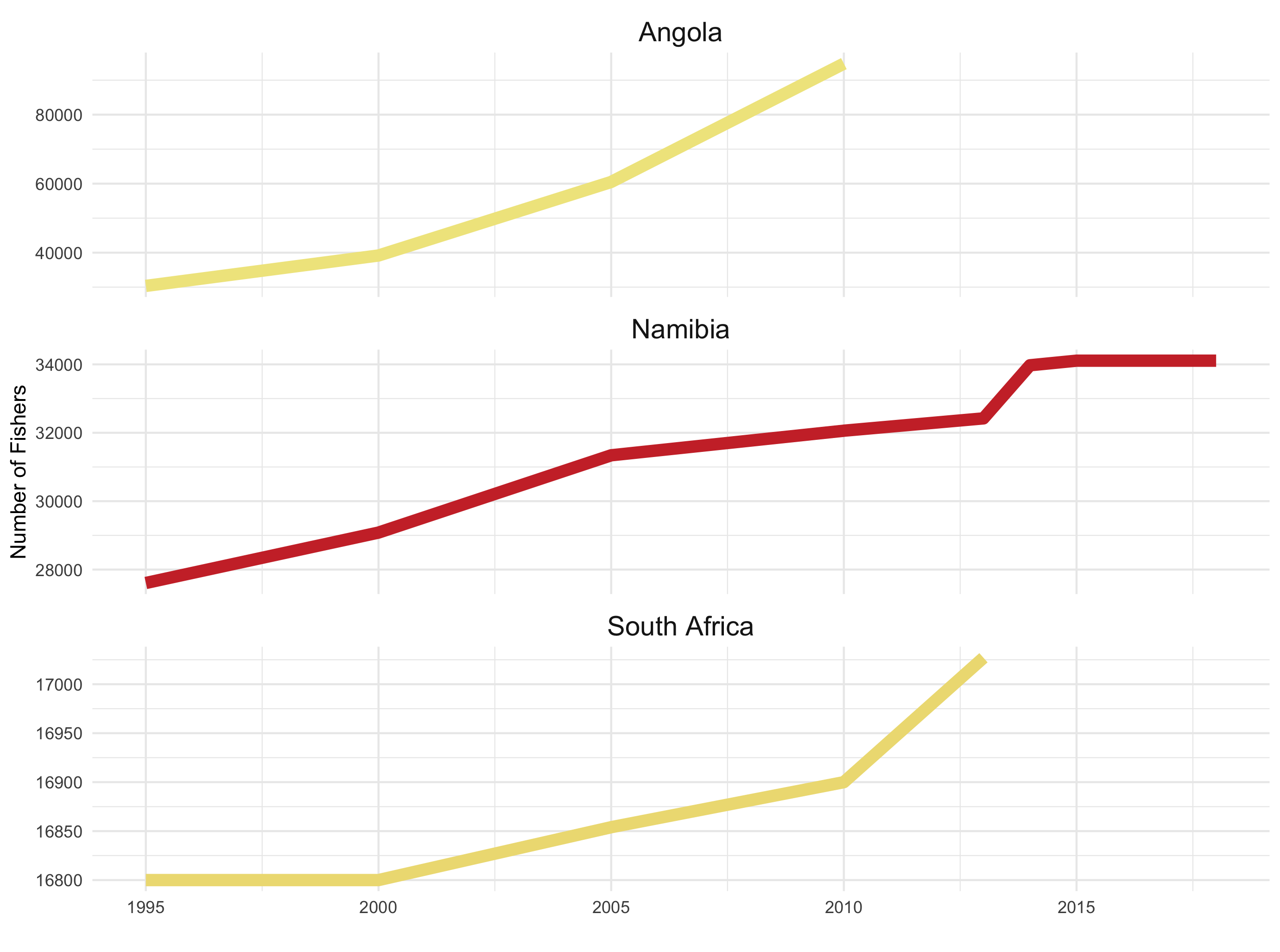
This means that fisheries are a critical component of subsistence as well as economical activity for the countries neighboring those waters. Not only that, but UN fisheries data show that the number of fishers and fishing vessels in the region has been increasing over time and both subsistence and commercial fishers comprise a notable portion of the entire labor force of countries in the region.
Map Legend, Share of Workers who are Fishers (%)
What is at stake with the fisheries?
Despite the large quantity of natural resources provided by the Benguela upwelling boundary system, historical conditions have impeded the economic prosperity of people living in the region. Nations in the region are only recently shirking colonization and apartheid in the case of South Africa. Furthermore, World Bank and IMF-enforced structural adjustments all over Africa have emphasized the export of primary goods, meaning there has been little investment of foreign capital in constructing infrastructure and manufacturing capacity for economic autonomy (although particularly in Angola, this is starting to change as China has significantly invested in large infrastructure projects, including ports, across the country).
Map Legend, GDP Per Capita relative to United States (%)
Until capital and infrastructure has been secured, fishing remains an important industry for primary product exports. However, climate change and a history of unregulated overfishing by large multinational corporations poses questions and challenges to this vital economic (and subsistence) enterprise. Climate change-related effects can harm fisheries by stimulating the formation of low-oxygen zones and by disturbing the development of fish larvae though ocean acidification. These uncertainties and potential declines in fish catch can potentially incite or exacerbate geopolitical conflicts.
Who is working on these questions?
Because the BUS is so economically and ecologically critical, it only makes sense that it would be a hot topic of scientific research, especially as we are only now developing technologies that allow us to collect detailed data at large scales. However, the countries conducting much of this research are not those in the region with the largest stakes in the future of the BUS and associated fisheries.
We conducted a literature search and found about 500 papers on the BUS in the NCBI scholarship database.
Map Legend
Green Edges represent papers by connecting their country of publication with the area being researched (the Benguela Upwelling System).
Blue Edges represent papers by connecting countries where authors collaborated on a paper together.
Map Legend, GDP Per Capita relative to United States (%)
Parachute Science
Among those, the vast preponderance of authors conducting those research studies were from (show table with top authorship countries) the US and EU member states. Recently, scholars of the philosophy of environmental science have deemed this phenomenon 'parachute science'. 'Parachute science' broadly refers to well-funded laboratories from wealthy (predominantly white) countries sending scientists to conduct research on areas in the global south, without involving any local scientists or knowledge, and then sharing those findings in the narrow scope of a scientific community that may never reach the people who stand to benefit from it.
Parachute science is the result of the same historical conditions that led to the current economic disparities we showed earlier. The institutional funding, expertise, and authority to publish findings in prestigious outlets continues to be held by older western institutions, while research institutions in recently decolonized nations don't receive the same type of investment or consideration.
We strongly hope that future scientific research in the US and Europe doesn't continue the 'parachute' pattern. We urge members of the research community in the west to call for more international relationships designed to support research programs in recently decolonized countries without exploiting them.
Supporting expansion of marine science research internationally will stand to benefit the global community by empowering better stewardship of one of the world's largest fisheries.
From the northward blowing wind along the shore caused by the land-sea contrast and the direction of the Earth's rotation, to the transport of cold, nutrient-rich water to the ocean surface, to the growth of so many millions of individual phytoplankton that we can see them en masse from space, there is much more to be learned about the Benguela Upwelling System.